The Ladakh Reflections - Day 3

Another lovely morning and it is glad to be in Ladakh this time of the year, the sun is out and so am I and so was Lukkaey (Nawang's poodle dog). Nawang is working on the small field enclosed inside the house. One could see the small apples and green apricots growing in the short summer sun. On the small furrows in the field are vegetables like carrots, onion, spinach and some that i could not figure out. The flowers are in full bloom and so are the many colored rose bushes. It is summer and they have this short hiatus to grow before the frigid winter shuts down life again. We had our breakfast and the kawa before we set out again. My friend has some social commitments early in the day, so I will be on my own to roam around the city. First we went to the DC office that is near the Polo Grounds, Leh for getting the inner line permit for me. This permit is required to visit front line border areas like Pangong Tso and Nubra valley for Indian as well as foreign tourists. Nawang knew his way around the office so this was accomplished in real good time. I wonder why they still have it necessary for Indian citizen, but that is a separate story. Since my friend had to go, i asked him to drop me to the fort overlooking the Leh town which he promptly agreed. After a drive across the city and a long curve to the hill top, he left promising to meet around 2pm.

( apricots warming up in the summer sun)

(Namgyal-Tsemo, the white fort above and red temples below)

(Leh Palace)

(The flag alley at the fort on Namgyal Tsemo)

The fort and the Gompa (Namgyal Tsemo) are a three structure building with the white fort on the top and temple below, the main attraction being a tall figure of Maitreya Buddha in the red temple. Some of the best views of the Leh town are visible from here. The young getshul (novice monk) distributing the entry ticket volunteered to take shots for me. He told that this was built in 15th century and spoke pretty decent English. After the temple, i continued climbing to the fort, and since the fort was in ruins, the way up to it was unkempt and dangerous and most likely closed. Multiple times i thought of returning back as a fall from here would surely land me some place that i do not want to go. Anyhow i reached the top which had nothing of mention except dilapidated walls and rocks strewn over the place. There is a perimeter around the castle top, made of wood logs on the sides and below with sacred flags waving rigorously in the wind. I took the chance of walking around it even though it looked precarious and i named it, the flag alley. The way down was equally nerve wracking and sometimes i had to use my arms as well on sharp corners. By the time i reached the temple i was a little weak in my knees. From here, one can have beautiful views of the Leh town, some places green and some new settlements that were not so green. Also visible was the long and winding trek that i had to take to reach the Leh Palace down below. I could see backpackers climbing up this criss-cross trek. I started rushing down, but before i could go further i saw a trek going in another direction to a small hillock beside. Since i had time, i decided to go this way. At the top, were prayer flags (called tarshok locally) fluttering in the blue sky that stretched out to the fort that i just visited. Their red, blue, green, yellow and white making it a riot of colors. From his small hill, located outside the boundary of the village i could see small structures strewn randomly on the landscape. These are the Buddhist cemetery, where they burn their dead. I started my arduous trek down and it wasn't much difficult walking and sometimes running down the mountain provided you had good shoes. While the slopes were bare, there were small herbs growing wild and there were patches of violet bloom that looked like lavender. The Leh Palace, built in 16th century is a nine storey palatial building mostly brown. Imposing as it may be from outside, the interiors again are crumbling and mostly empty. There is a small temple inside, where apart from the usual figures, ancient religious text are marked and stored in red cloths onto a rack, just like a modern catalogue. On the walk below to the city, i visited two more temples, the Chamba Lakhang which had a 3 storey figure of the Maitreiya Buddha and the Chandazik Gompa where there were nice frescoes painted on the walls, an array of miniature Buddhas lined in rows across all the walls. These can be given a miss when you are running a tight sight seeing schedule, but that is not the case with me. I am here for the sights, for the sounds, for the culture, the history and the geography and in no particular hurry. Couple of things of mention the stocks of cooking oil bottles inside each place of worship and all the temples had offering of what seemed to be water in seven bowls in front of the holy figures. I asked Nawang later and he told, the cooking oil is in fact the offering to the deity that people bring to the temple and the clean water in the seven bowls are symbolic of seven tasty dishes offered to the gods every day.

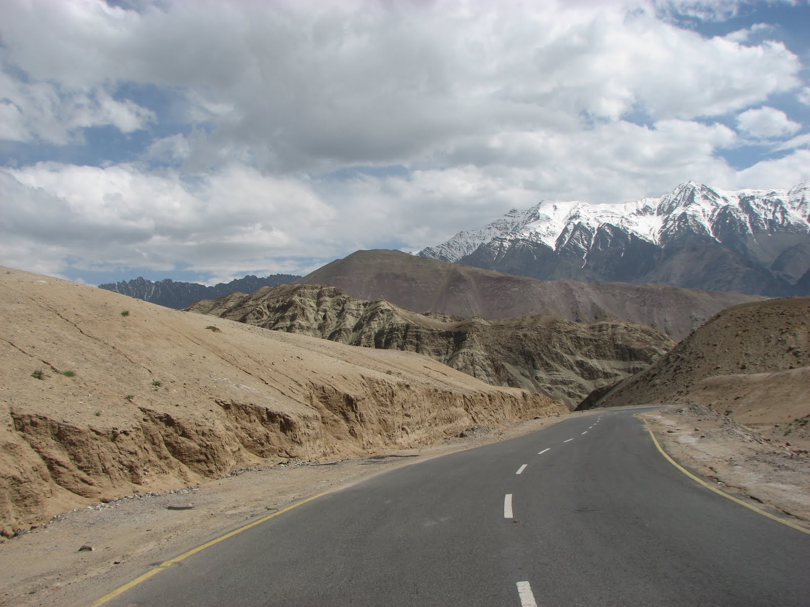
(The long trek from the Namgyal temple to Leh Palace)

After covering all that the complex offered, besides the Shankar Gompa which was closed at this time i walked the narrow lanes to reach the main mosque in the city center. After a while, Nawang joined me and we went for a lunch nearby in a restaurant. He ordered for me as well, which was what locals called as Mix (half plate of Thupka i.e. noodles with mutton and 2 big momos in it). It was scrumptious especially with the very hot chili sauce. We roamed around the city, mostly in antique and local jewelery stores to find something cheap and worth taking along. There was lots of stuff that one liked, but the prices were exorbitant i must say. I did buy a bracelet for myself that had some signs etched out along its length. Couple of Nawang's friends joined us and we went to an array of similar looking tea shops owned by people who migrated from Kargil. Inside one can get seated and enjoy the Ladakhi salted butter tea with some Kashmiri bread over evening banter. It seemed to be a place where one would come down after a hectic work day to unwind, to talk over a cheap cup of tea and then leave. The tea tasted unlike anything i had till date. We soon left for Polo grounds, where there was a football match being played out between the local teams. We watched most of the first half and i wondered what kind of stamina is needed to play hard at such heights and rarity of air. They are born with stronger lungs, i suppose. We left during the half time, back to the home for the evening tea. Sami (Oh! did i not introduce her, she is Nawang's wife) meanwhile had brought mutton samosas for us, and they were awesome. They were such a delight to have over tea. We watched the news and the debacle that was playing out in Srinagar streets with bullets and stones.

We again went out to the market to confirm my tomorrow rafting booking and timing and the market was teeming with activity. I could see the traffic jams and we had a really tough time finding a parking spot around the city. Gosh! of all the places on earth, this is Leh!. Anyways it is peak of tourist season and in another three months all will be gone and the city will return to its usual slow life. But for now, it is raining people! The city and its economy is mostly dependent on tourism, with most of shops and businesses being antique shops, money changers, guest houses/hotels, cabs & tour operators. We completed our work and rushed back for the Japan v/s Paraguay that was waiting for us in the comfort of the home. Over halftime, i asked Nawang as to what the signs etched in my bracelet really mean and he was kind enough to write it out for me. These are the eight auspicious symbols in Tibetan Buddhism.
- lotus flower : for purity
- umbrella : protects from vices and evil
- victory banner : victory of Buddha's teaching over one's evil
- endless love knot : tranquility/equality
- two fishes : flexibility in teachings of Buddha
- corn shell : call for the worship/Gods
- wheel : Buddha's Dharma
- vase : vase of nectar

Not a bad way to end it, especially on a slow news day!

The Ladakh Reflections - Day 4

(The view from the Leh-Kargil road)

(Spectacular terrain just before Nimu on Leh-Kargil road)

Today is rafting day! Got up early as had a pick up at 8:15 am. Did a quick breakfast and packed an extra pair of clothes for change just in case. The rafting operator was Splash Ladakh which had host of other packages as well. The taxi stopped at couple of more places to pick up other rafting enthusiasts and by the time we were done, we had an American, two Danes and two Indians besides me. I had a nice little conversation going with the American and the two guys from Bhopal. Out of the city, we took a right to the road that goes to the airport and Kargil beyond that with the Indus on our sides.The first destination was Nimu, a small village on the Kargil road that would be serve as the stopping point of the rafting exercise. As we moved out of the city, we were again with the mountains, the clear blue sky and the clouds. The big blue country indeed. One could see the road for miles and miles ahead. We sped by what was a Indian oil cylinder refilling complex. The hills on both side were a lot smaller and there was some rain drops on the windscreen even though there were no clouds over us. The road was darkened by the this invisible rain but the rest of the environs, the gravel on the sides & the hills remained the same. The road was straight and we drove fast, until the driver took a shortcut from the highway for Nimu village. The road was now sloping down sharply across sharp turns and blind corners. A little forward and the terrain changed to mud hills with small round rocks embedded in them like a river bed and there mud hills encroached on the roads. It was a surreal feeling as if straight out of moon or mars, except of course the road. All you could see were severely eroded hills around and rocks strewn around. Occasionally you could make out arches shaped structures in these mud hills except that they were caused by erosion. I wondered what it would be like to get lost here on a full moon night when these mud hills impose gigantic shadows. Clearing out from this terrain, I could see a splash of green on what was Nimu village (28 km from Leh) and i could see Indus all over again. The slow place of the river allowing it to make sand islands in between its midst.

(Zanskar river from the Nimu-Chilling road)

(Zanskar river from the Nimu-Chilling road)

We took off again for the starting point of our rafting which was Chilling village (60 km from Leh) on the banks of river Zanskar. We crossed Indus again, and left Ladakh range for more treacherous Zanskar range. No more smooth gravel hills, instead we had sharp edged rocks jutting out dangerously on the road. After a short while, the river Zanskar meandered across besides us with it cream colored water. The road to Chilling had the deep river on one side and the rock face on the other, besides the road was not as good as the Nimu stretch as it narrow and had lot of blind turns. Anyways, it did not matter, i was more occupied with my camera. We crossed the Zanskar river, but still drove besides the river but now on opposite side, and were gaining altitude. The river was slowly getting rougher and you could see eddies and currents in it. One could hardly see the river beyond hundred meters at any point of time, because it was doing zig zag between the mountains. Over looking the river, the many colored mountains look ominous & dark and pregnant with intrigue. I wonder if one would survive if the raft crashed against the sharp edges on the river banks. The driver told that we had reached Chilling and the starting point lay 3 km beyond Chilling. I somehow was more interested in traveling the road to where ever it took us rather than rafting. After more than 2 hours of leaving Leh, we reached the starting point (around 11am). Couple of more jeeps were lined on the sides, while one with the gear was parked right besides the river. It took an hour for them to take out their gear, ready the rafts and for us to wear the suits, helmets and waterproof. After a quick introduction by our raft guide(is there a proper term for it?) and the safety guidelines, we were on our rafts. There were 3 rafts in the water besides couple of safety guys on their kayaks.

(Starting point of the rafting)

(view from the raft)

The water was sure cold. Besides me, there were the guys from Bhopal, two ladies from Bombay and a father-daughter duo from Ranchi. Since the water was fast, all we had to do was steering the raft to avoid the edges and the eddies. The current did the rest of us, meanwhile i enjoyed the spectacular view the Zanskar had to offer. The mountains gave way to more mountains which in turn gave way to more mountains. Again, there were huge alluvial fans on the slopes caused by erosion and shades of violet color in the hills besides the usual brown. There were differences in terrain as we drifted in the river, sometimes one could see chocolate colored rocks on the sides all smooth and shinning as if someone has polished them, sometimes you saw the slate and the shale jutting out from underneath with perfectly preserved layers. Yet other times you could see the sand and pebble mix hills on the sides that looked lot like a biscuit with nuts in it. With all that rest you did between the rapids you had enough to enjoys the sight all around you and since i was alone in the group, i did not mind that i had no one to talk. The rapids were good and some of them did require maneuvering to avoid the eddies or slamming into the edges. Thankfully the guide was good at dictating short commands for us to follow. He told me that the Zanskar stretch is more difficult to do then the Indus stretch, besides there is not much water in Indus this time of the year so it would not be that much fun. He said that these are Level3 rapids and some are 3+. At the midway of our rafting around one and half hours into it, we took a short break along the somewhat smooth banks. I unzipped my booties and baked my near frozen legs on the hot warm sand and rocks nearby. It felt so good. I pulled a loose shale stone from the ground like a book from the the library rack and flipped its thin layers hoping to get lucky with a fossil or two. Some wild flowering grew in the sand. Meanwhile the refreshments were out now for all to eat. Another 10 minutes, and we were again in the river. The water was fast and it created small caves at the edge of the rock face where the water meets the banks. Couple of thick wires passed over our head and when i looked back, i could see a small iron chair on the other side of the river tied to the wires and this was the way to cross the river to go to the isolated village on the other side. Pretty dangerous, i thought!. I was still not sure if it was the right time to take out the camera holstered in water proofing as the water was still unruly. I was glad that we did not had much work to do ploughing the water, except when the rapids approach otherwise this terrain would leave you seriously out of breath. Overhead the bridge through which we crossed Zanskar passed us. After an hour in water, the water calmed down and i took out my camera for some shots of the environs. The river required more paddling now as the current was slow. I could see the willows of Nimu from the distance. It was 3 p.m now and we had reached Nimu, it took us a little less then 3 hours to complete the route and we were all tired and more so due to the heavy lifting that we had to do to take the raft out from the water and into the gear area. We got out of gear and a hot lunch awaited us besides the Indus banks. It tasted nice, i guess any thing tastes nice when you are so tired. The usual dal, chawal, matter paneer and couple of other side dish. It took a while before the lunch was over as the foreigners had to work their way around Indian food just as they had to do on the raft.

(The gates of hell are not very far from the gates of heaven)

We left for Leh around 4pm back on the Leh-Kargil highway, following the same route from where we came. On the way back, saw a tilted and accident stuck qualis by the roadside, a piece of heaven can be hell for some i wondered. As soon as i reached home, we talked about my experiences over many cups of kawa, before i took a break to rest. Nawang told that on the same river that we rafted today, in winters there is a trek called Chaddar Trek that goes from Chilling to Zanskar and the trek in over the frozen Zanskar river. In the night we all took off to "The Tibetan Kitchen" in the center city for a nice hefty original Chinese dinner over beer. To a day well earned. Cheers!!

The Ladakh Reflections - Day 5

(The Leh-Kargil highway)

(The polished Leh-Kargil highway)

All the tiredness of yesterday is gone after a long good sleep. In the morning itself, Nawang and I go out to the narrow lanes behind the guesthouse to the Shiite muslim Kashmiri bread makers. They seem to be awfully busy given that all they make is this one bread. In their nondescript shop, all they had was bags of flour and one oven. There was a huge tree besides the shop and the placard said that this tree was planted by Guru Nanak when he came to Ladakh. After some basking in the summer sun during which my friend was completing some work that came up, we took off for Alchi which again is located Kargil highway some 40km beyond Nimu village. Just outside of the city en-route to Kargil, beyond the airport lies the Spituk monastery on the hill top besides the Indus. As we drove towards Nimu we stopped midway to a big gurudwara that was built in this wilderness. On the other side of road were flight of stairs leading to the hill top. This gurudwara (called Pattar Shahib) is now being maintained by some Sikh regiment of the Indian Army. Legend has it that a devil threw or rolled down a rock from the hill top to Guru Nanak who was meditating. Instead of harming, the shape of Guru Nanak's back was etched on to the rock when it hit Guru Nanak, and hence the name. I took a quick darshan, and continued on our sojourn.

(Basgo village and Basgo monastery)

(shades of Basgo village)

We crossed Nimu, towards the Basgo village. Just before Basgo village, the colored mountains became more multi-colored. I saw green and i saw rust red among others. It was such a sight to see so much color in a single frame. We drove past the lush green fields that was Basgo village and precariously perched Basgo Monastery. Nawang told that monastery is part of the UNESCO world heritage site and it has a gold and copper guild of the Maitreiya Buddha inside. The road beyond Basgo was full of places where you felt like to stop the car and take a shot or two for its unparalleled landscape and the multitude of shades. The road was very good considering the terrain, but some stretches were being constructed. The Indus meanwhile faithfully kept by our side. After a while, the village of Saspol came which seemed to be a big village as it had a bank in it. Just outside the village i saw 3 similar shaped stupas but all colored differently. Nawang explained that these 3 stupas signify the Buddha trinity, The first one and on the left is Orange, which is the Buddha of wisdom, the center one is white and called Buddha of compassion and the one on the right is colored blue and is called Buddha of power and energy. He also explained that the twelve main events in Buddha's life have been compacted into eight events and hence at places you will see set of eight stupas, also the eight stupas will be slightly different in the way the steps below the round dome is constructed. We turned left and got off the Kargil highway, to the Alchi village(70 km from Leh). Crossing the Indus, and another short drive you reach the small village located on Indus southern bank that has been put on the global map due to the murals and frescoes that the monastery has. Nawang told that foreigner make it a point to must visit Alchi due to its pre-eminence in Buddhist wall paintings.

(scenic Alchi village)

(copy of the mandalas at Alchi)

The Alchi-Chhoskhor as the whole complex is called is a set of small temples built mostly in 10th century and painted with thousands of miniature sized figures of Buddha. This is a fine example of Tibetan and Kashmiri arts and was built at a time when Buddhism was hardly known in Ladakh. Photography is strictly disallowed here. The first temple is Sumtsek temple (literally meaning 3 tier temple) for it has three storey, but it is not allowed to climb up to upper tiers due to weak structure. On three sides, there are large figure of Buddha with Buddha's life history meticulously painted on the drape that covers the legs. The rest of the walls are covered with thousands of Buddha miniature art. The pillar angles supporting the structures are also innately carved with mythological snow lions. There is a lot of detail in these miniature paintings as if built over a long long period of time, but the poor lighting is hardly a help here. The second temple is the Vairocana (who is central deity in the five Dhyani Buddha and is also called as Celestial Buddha) temple. This temple also has wall paintings besides extensive wood carvings. Another feature is the mandalas that have been painted on the walls here. Mandalas as Nawang explained is a microcosm of the universe and it has a cosmological representation, it looks like a square inside the concentric circle with brightly decorated art. The mandalas are used as an offering of the universe to the Buddha and each intricate detail has some symbolic meaning, often on more than one level. The other two smaller temples Lotsawa temple (dedicated to the translator) and the Manjushri temple (with the wisdom Buddha in all four directions holding sacred text and a yellow sword). Both these temples are in a state of decay and some of the wall murals are lost while others have been carelessly redone. We took leave of the temples and walked towards our car, the fields besides us had near mature wheat ripening in the summer sun.

(Where to stop, what to shoot.Every frame is worth capturing)

(confluence of river Zanskar and river Indus)

As we left Alchi and back to the the highway towards Nimu, the slanting rays of the sun made the hills look more spectacular. We drove past Basgo in no time, and took another route back to Leh. En-route, we stopped at the confluence of Zanskar with the Indus. What a sight that was! The small light green river merging with the cream colored and more larger Zanskar and yet Indus gets to keep its name despite being smaller. Probably Indus comes from a lot behind (in Tibet) and so it is longer that's why it gets to keep the name. Nawang told me that there is a perceptible temperature difference between these rivers with Indus being less cold than Zanskar. Besides Zanskar has lot of minerals dissolved in it and hence it is unfit for irrigation unlike Indus. We took some great shots and drove again until a small yellow sign announced that this was Magnetic Hill. I had heard of this place before, but was not willing to give it a try. So again couple of shots and we were off.

By the time we reached Leh, it was evening tea time. I took a small rest and we were out again in the market checking out the tour operators for shared taxi for Nubra valley or Pangong lake tomorrow. It did not took us long to confirm tomorrow trip to Pangong lake. Nubra can wait for now. We went back home where delicious mutton curry and delectable green vegetables were waiting for us for dinner.

The Ladakh Reflections - Day 6

The alarm clock buzzed at 5am, and i had to be at the pick up site by 6. I rushed to be ready by then. The taxi came dot on time, we picked another three people on the way. A young couple from Bangalore and a lady from Delhi. I was excited as today we are going to Pangong lake, the most must-see place in Ladakh. I tucked multiple xeroxes of inner line permit and was full on all possible camera batteries. We followed the same route as we did when we went to Thiksay. We drove really fast up to Thiksay, because all the driver did was drive, not a word about what just went by or what lay in front of us. I missed all the tiniest of detail that Nawang would tell. Beyond Thiksay, on the banks of Indus lay the monastery called Stakna located on a hill. Stakna means the tiger's nose and probably the hill is shaped like one. We stopped at Karu (35km from Leh) for the quick breakfast.

(state of the roads at Chang La)

(Chang La pass at 17586ft)

From Karu one can get fabulous views of snow covered peaks nestled between barren hills and the greenery below. We moved on indifferently for other wonders awaited us. On the far hill top i could see another monastery that looked lot like Thiksay. This was Chemde monastery (of the movie Samsara fame). We had left the straight road behind and the drive now was steep up the mountains. Down in the valley, there was the beautiful village of Sakti, the only patch of green in the all encompassing barrenness. Through the wind screen, i could see line of other tourists jeeps moving higher on those curves in the mountain ahead of us. A very long curve and we would be there, nothing would have changed. We would still be in wilderness and barrenness would still be same but we would have gained couple of hundred feet in altitude. I have traveled hundred+ kilometer in all direction from Leh and i am overwhelmed at the vastness of this cold desert and the scale of it. I awed at the thought that same landscape would greet me if i go to Tibet and it would be thousands of miles across. I want to see it someday. The milestones constantly reminded us that the next big village would be Zingrul (60km from Leh). From the distance i could see the clouds high up in the mountains in mood for mischief. In the light brown mountains that we just crossed, i could see the roads carved randomly on the sides like with a stick on sand dune. As we continued to gain altitude, we were driving on mountains that had snow on its higher reaches. We reached Zingrul which was not much of a village, some army buildings here and there.From Zingrul onwards the ascent was really steep and though initially the road was good, it started getting bad now. There was spattering of snow here and there on the slopes though the road was dry. We were now in midst of the clouds and mist and though i and co-passengers were elated, the driver fret-ed about the approaching bad weather. He told that the colors at the lake would not be great if it continued to be overcast at the lake. The high pass which was visible some moments ago was now shrouded in clouds. The snow on the slopes were much more uniform now and the road much more worse. Occasionally the stretches of road were marked as avalanche prone and on those stretches the snow was over 10 feet high besides the road and running water forming icicles. Sometimes it was not even the road anymore, all you could see was streams of snow melt rushing down across the broken road with the shortest path possible. Everywhere your eye could see there was snow and it was so bright without the sunglasses on and that to on a day when the sun was hiding behind the clouds. One last turn and we enter what looked like a wide stretch of road and semicircular steel dwellings on both sides. The milestone proudly displays that this is the Chang La, world's third highest motor-able pass (75km from Leh). We stopped there, the Bangalore couple seemingly over-excited about the snow. Later they told me that they are seeing snow for the first time in their lives. On the middle of the road was a shrine dedicated to Chang La. There is small tea-counter besides a medical facility here. It was very cold here, and i had to pull my jacket before i could venture out. I felt good to feel snow at the height of the Indian summer and wondered what it would be this time in Delhi. Couple of army men with heavy boots and sunglasses rested on the wired fence. 4-5 more tourist jeeps arrived now. There seemed to be melee at the pass center now. I meanwhile was busy with my camera and talking to the driver. Just behind the pass from where we came was an impressive snow covered slope looking a tad dull in the overcast weather. Chang La pass is next to Tanglang La (which is 2nd) and stands at 5360m(17586ft) at the high point. That is some menacing height considering that Mussoorie with all its fame is just 2000m high. After staying for another 15 minutes which was enough to give the couple traveling along a headache (probably due to rarity of oxygen) we started out descent down the pass.

(The various shades of Chang Thang region)

(A himalyan marmoot)

(The colors of Chang Thang near Tangste village)

As soon as we left the pass, the weather turned inclement and it started snowing. Not very hard, but enough to make you feel good and joyful. The road though still terrible was slanting down now slowly. We slowly made our way past Tso Ltak, which was another military installation. The snow was no more now either falling or on the slopes and the road had remarkably turned good. This was Chang Thang territory (meaning large northern plain). The mountains has so many shades exposed, one wonders was this all intentional. Did almighty create this for us to relish. A small river flowed along side the road as we drove towards Tangste village. Occasionally a small lake would on this river and you wished you could stop the car and go down to the edge of the lake. There was a green carpet where ever the river flowed, with the meandering river in between. Occasionally on both sides of the road, there were huge rocks with the road carved in between, probably rocks is not the right word. It does not properly signify the scale of what you saw. They were like whole hills that appeared to be a single big rock. We stopped at Tangste for the permit checking, before driving off again. One diversion from here goes to Chusul (another 80km from here) famous for the 1962 India-China war. The locales were still spectacular and the green valley with the river was lost in the mountains to be replaced by another river, this time of gray sand. As we drove the entire length to Pangong lake, this river of sand was by our side. Probably this is snow-fed river that feeds the Pangong lake as i hazard to make a guess. In such desolate environs even the river of sand looked to be an eye catching spectacle.

(at the edge of Pangong Tso)

(at Pangong Tso)

I caught a glimpse of it. A deep blue patch just barely visible in this absolute ruggedness. Another couple of minutes and we had arrived or rather the lake had arrived in our senses. A think blue streak of endless water cradled between the mountains, as far as i could see. The water was so calm and quiet as if hiding a million secrets underneath. We drove a little while besides the lake, before alighting. It was such a majestic view as if somebody had painted with the choicest of colors that would look best. Nothing more need to be added and nothing more needed to be removed. Maybe it was for the Gods only to view and we are fortunate few. I went down to the lake, the water was icy cold and crystal clear. A flock of birds swam effortlessly in it. On the other side the smooth brown mountains seamlessly merged with the lake as if in perfect symphony. I sat down and wondered why such pleasures have to be fleeting and why we whiz past them for inconsequential goals. Wouldn't it be nice to have a home whose window opens on the lake, or maybe one window opens on the lake, the other on lush valley of Nubra and another on icy peaks of Stok Kangri and so on. I reigned in on my flight of fancy and climbed the higher ground for some better shots. From the distance it looked like a postcard, all the elements in absolute harmony, in perfect awe of each other. Everything was so serene and quiet. Not a wave, not a movement anywhere as if frozen in time. At the start of the lake the water had a tinge of green. Whenever the sun was out the lake looked blue and when it hid in the clouds, it was in shades of gray. My camera furiously worked overtime to make sense of it all. This lake is 130km long and not very wide across and at 4300m altitude.More than 60% is under Chinese control. Someone volunteered to take couple of my shots. After spending two hours on the lake, we started the long haul back. The driver told me that tourists who come here to spend a night are taken another 12 km along the lake to Spangmik where tented accommodation is available. I wondered if there are water sports activities there. It would be such an experience, taking to boat midway and enjoying the pristine views around.

It was already 1:30pm by the time we left the lake. Leh is a good five hours away. It was decided that the lunch would be Tangste, a hour drive from here. The river of sand by our sides as we drove into the panorama called Chang Thang. We drove by Tangste monastery on a hill top looking old and dilapidated and yet surreal. The driver stopped in front of what looked like a eatery. The lady told that we can have our lunch in their house instead of here. A door besides the eatery took us straight to the main hall of their house where we seated ourselves comfortably on the carpet. We had simple yet delicious dal-chawal-subzi before we took leave. In the outskirts of the village, amidst all that green one could see domesticated horses and herd of pashmina goats grazing. A camp of nomads housed in circular tents passed by. A little forward a group of yaks were indifferently grazing while travelers stopped there jeeps to take their photographs. We promptly did the same. Hardly we had started again, when the driver pointed out in the field. A Himalyan marmoot was sitting as if monitoring traffic. As soon as we stopped and open the door to take pictures, it rushed forward and raised its forward two legs raising its nose in the air as if to get a scent of something. The driver told that the travelers have taken to feeding them therefore they are not scared of come near people. From Tso Ltak the ascent was pretty steep. Since the sun was out brightly, the snow that fell earlier in the day was melting fast and those small streams of snow melt that crossed the road to the slope below were now gushes of water. The jeep cautiously navigated to avoid the bigger puddles but the road was such bad that any amount of going around would not help.The driver told me this pass is the most difficult to maintain of all the passes and looking at the terrain i seem to agree. We stopped at Chang La for 10 minutes to give our backs some relief from the beating it took on this treacherous road. The drive from here to Leh (another 75km) was rather uneventful, besides i was feeling a bit sleepy due to the sunshine that was warming me up from the window and the windscreen.

I reached home around 6:30. Nawang and I talked and examined the results of the day (the photographs) over cups of kawa. He also told me that tomorrow trip to Nubra Valley has been arranged and i need to be ready by 8 in the morning. A little TV besides a big dinner and serving of fruits to wind up a glorious day!

The Ladakh Reflections - Day 7

I packed some clothes and essentials as Nubra valley would be an overnight stay. I reached the pickup point by 8am. The jeep came a little late and since i was the last to be picked up, i guess it made up the lost time. On the jeep there was a father-daughter duo from Wales and a honeymoon couple from Mumbai. We drove a different route this time, as Nubra lay in the north of Leh. Unlike the other days when we drove a straight road before the ascent, it was straight up from the start. As we moved higher and higher, the Leh valley grew smaller with every turn. In front of us on the mountains, one could see the thin drawn line across the brown slope and extending to the other mountain where it was remarkably more visible because it distinguishable amidst the snowy slopes. That was our way. We jumped from one mountain to another, i guess never quite going around them. We reached a small hamlet of South Pullu, beyond this we could see the high pass (Khardung La) unaided. The thick snow covered the slopes now and the snow melt melted and flowed across the road in million small streams. The road was a little better than yesterday, but still bad enough to constantly make the camera move rigorously during taking pictures. Sitting besides the driver, one could see how close the precipice was, sometimes we drove just by the edge of the road which gave me some heart stopping moments. Some more anxious moments came whenever he seem to change music between those blind turns and razor thing edges. From here the clouds again seem to be working overtime at the Khardung La.

(road down from Khardung La)

Some more long curves and we reached a wide open space which was Khardung La pass (40 km from Leh). It is the highest motor-able pass in the world at altitude of 18380ft on the Ladakh range. This pass had existed for long and was used by travelers and merchants on horses to connect Yarkhand (in Chinese Xingxiang province beyond Karakorum pass) to Leh on the Kashmir leg of the fabled Silk Route. In seventies the Indian Army made it motor-able. This pass is of strategic importance as it is main link for Siachen war theater and beyond that to airfields like DBO (Daulat Beg Oldi) just on the Chinese frontier. The cold was not as severe as yesterday and within 10 minutes of our arriving here another ten jeeps came filled with tourists. It seemed like a highest traffic jam possible anywhere in the world. I took some shots and walked on both sides of the road to see what hidden view lay there. There were only smooth snow covered peaks across patched with shadows from the clouds above. A milestone declared that Siachen base camp was another 164 km from here. I wondered what it would be like there, on the glacier. Standing in the mild sun, i was done with all the photography. On the wall, the daughter from the Welsh duo traveling alongside was doing all kind of antics for the camera. The father told me that she loves snow and goes to Austria every winter for snow boarding. We immediately stuck a conversation on China, on Welsh country side and his experience here. He was on his 10th trip to India and seemed to be a practicing Buddhist. Over our heads the snow like bread crumbs started falling. On the jeep hood, I for the first time saw the actual shape of the snow before it melted quickly on the hood. I had seen snow flakes so many times, but this is the first time i saw it in crystals shape that i had been taught in school. Probably the snow was always crystalline but this time the crystals were so big to be seen clearly. I stood there watching them fall on the warm hood of the jeep and disappearing. The driver was getting impatient as the honeymoon couple was nowhere to be found. I guess it feels good to be newly married, no care in the world. He went out to look for them. At this extreme point in the world, i assure you it won't be easy. It was such a crowd at the top now. After a good 40 minutes at the top, we started our descent downwards towards Khalsar (56 km from the top).

(The river, the sand, the valley and the mountains)

For quite some distance, a wall of snow lined on one side while smooth snow covered slope on the other. We passed by the village of North Pullu uneventfully. Beyond that the snow had gone and we were slowly descending on those long and short curves. We stopped at Khardung village for permit checking. Couple of bikers along the roadside had all possible gear that you can think of on them. From here en-route, we passed some spectacular view of brilliant relief carved on the solid rock by the river. There was a streak of greenery between the all pervading barrenness and brown mountains though numerous were far and wide as if inviting us into their laps. After a sharp descent over a short time, we were traveling besides a large river bed. There was frequent green cover and the river meandered across the vast bed through many paths. The color of dry and wet sand, besides cream colored water created artistic contours and smooth curves as if the artist had used various shades of a simple pencil to capture all this imagery. Occasionally green added to the frame. This was Shyok river, one of the bigger tributaries of Indus which joins it somewhere in Pakistani Kashmir. We drove along side until Khalsar village. Just beyond it, the road splits into two. We continued along side the river though on the higher plane to Hunder village where we are going to stay for the night.The terrain on the side of the road though rough, looked grainy and loose and white with fine chalky powder covering the roadside. On the other beyond the river it was dark brown. A little further it was rocky and solid, a further while it was brittle with layers jutting out. To me this place seemed to be a geologist's paradise. I am sure there must be some mineral wealth hidden underneath this vast expanse. From a distance high in the mountains, a thin sliver of water was flowing majestically down down a sharp crevice in the mountains. Slowly we drove in its direction until we were directly underneath it. The water which came from the snow melt from even bigger mountains behind it was hardy a trickle but it was enough to cut features into the hard rock.The water flowed straight into a water tanker parked at the base. We were now traveling just besides the huge sand river bed of Shyok and passed by Dishket village. The driver informed that we will return to Dishket tomorrow morning. Beyond Disket, one could see sand dunes on the banks of the river bed. These were Nubra sand dunes. A short drive and crossing a bridge guarded by armed army men we entered the dense green village of Hunder. A small but noisy river flowed and merged ahead with the Shyok.

(double humped camel sitting at the floor of Nubra valley)

(Nubra sand dunes besides river Shyok)

It was beyond 2pm by the time i checked into the home stay called Goba. The rates were okay and room though big was minimal. We had fried rice for lunch seated under the apple trees outside along with the duo from Wales. It was decided that all would rejoin at 4 for the camel ride. I had an hour to rest even though i was hardly tired. In my room a very detailed map of Ladakh kept me very busy. Geography and maps were my favorite subject in my school days. I still felt like a kid with eager eyes. We were joined by an Italian lady for our short drive to the sand dunes. She was a working for Italian travel operator company and based in Delhi for 3 years. On the valley floor a herd of camels squatted looking visibly bored. I wonder what these camels did in the frigid winters. These are the Bactrian double humped camel from Central Asia. They are the left over of the flourishing trade that existed on the silk route between Leh and Yarkhand. For a large animal like camel they had astonishingly small ears. Their going rate was Rs 150 for a short 15 minute ride and though some were debating the virtues of it, i had no intention of missing it. There was no point in coming all the way to Nubra and not doing it. Meanwhile I and the Italian broke out into a nice little conversation on places worth seeing in nearby and Kashmir. The camel guide helped us on the camel and we took off to a flagged point out on the sand dunes. The ride though good and comfortable seemed like a bit overrated and the 15 minutes pitifully small. I had some shots taken riding on the camel and then besides the camel. An attempt to stroke them on their head would make them wiggle their head with irritation. I guess they don't like it here. In another half an hour all were done and we drove back to Hunder. En-route i tried getting a consensus to go to Panamik village (not part of the initial travel plan) as well the next day which was beyond Sumur and though initially everyone agreed, the plan fell through as the couple from Mumbai had to reach Leh early to do last minute shopping before their flight. Panamik village (20 km from Sumur) is known for its hot springs. I was back in my room 5:30 and disappointed that there was nothing else to see today even though we had time. I took off with my camera alone and not sit in my room. I found my way to the bridge between the stupas, the dense trees and various irrigation streams that branched out of noisy river nearby. On the bridge, i had a conversation with the soldier holding an INSAS rifle guarding the entry to the bridge. He asked where i was from and what i did and seemed to relate to Dehra Dun. He told that the road went to Thoise air force base (15 km from here) and Turtuk (another 75 km). Just for trivia, Thoise is airfield that supplies to Siachen and Turtuk (made it in news during Kargil war) was Pakistan territory until '71 war when it was absorbed into India. Just besides the bridge perched up midway in the mountain were two temples (Hunder temple) and a dilapidated castle on the very top overlooking the Hunder village. I inquired a local if there was a way up and he nodded in agreement. I decided to go for it. I started walking up briskly mindful of the fact that it was getting late and soon it may be dark, but then after a while i had to stop to catch my breath. It is so hard up here, even a little effort seems laborious. The trek up to the two temples was relatively easy as the path was well trodden and used. One of the temples was locked and other had a small prayer chamber with three figures of Buddha. I continued my way up to the castle though the gravel. The climb was more difficult now and the treks occasionally bifurcated into multiple smaller path leading to confusion as to which one would lead to where. Couple of places were real nasty, i looked down and could see the bridge far out. I wondered if the army man were watching me. After 35 minutes of near steep ascent i was finally at the castle which was locked. I rested to catch my breath. From here, one could see the complete village of Hunder and the small river merging into Shyok and the mountains behind lighted in the evening sun. Behind the castle, on a even higher hill, i saw another square mud structure. I debated with myself whether to go for it or not, especially as it was going to sunset soon and descending back could be tough on a ill-formed path even if it visible. I decided to go for it and in another 15 minutes i was besides the abandoned mud house after some very treacherous moments and double thoughts. I photographed at the same time as i grasped for breath hoping not to lose vital minutes. After staying for 5 minutes at the top, i started my descent down. Occasionally you could feel the weakness in your knees, but the descent was surprisingly fast and gentle except some corner where i had to use my all four limbs. By the time i reached the temple, i realized that i had ample time and it is not going to be dark anytime soon.I leisurely strolled down. There were maybe thousands of randomly laid out heap of plane stones arranged one over the another maybe as a symbolic image of a Stupa or meditating Buddha. I also made couple of them on my way down. Since it was still not dark i went to the river (Hunder Dok) under the bridge. It seemed like a perfect place for a small picnic, the one we used to have in our school days. The whole trek up and down took me around 90 minutes and i was drained to the core.

(Hunder village with perfectly lit mountains in the background)

(View of the castle and Hunder village from the mud house)

(Hunder village and Shyok river)

I returned back to the home-stay, where the dinner (veg thali) was ready. We had a long conversation over dinner, before the tiredness caught on with me and I took leave. I must say, the trek up to the castle (and to the mud house beyond it) was the high point of the day and i felt elated that i actually did it and not sit easy in the confines of my big room.

The Ladakh Reflections - Day 8

(The Disket monastery perched up the hill)

(Views of Nubra, Shyok, Sumur and Karakorum from Disket monastery)

(The interiors of Disket monastery)

I woke up 7am and packed up whatever little i had bought and in another hours time i was below the apple trees having my breakfast. The homemade apricot jam tasted particularly good. The Welsh told that their 3am wake up to see the milky way across the clear night sky was a disappointment. I was glad i did not tell them to wake me up as well. Around 8:30 we left to cover what remains of the Nubra valley. We drove straight to Disket along the river of sand and then curving up the rock to Disket monastery on the hill top. The monastery was just on the edge of a deep gorge whose depth i could not see. The main prayer hall had many images of deity and most had their faces covered with cloth. The central deity was an terrifying image of Guhya Samajya with three heads positioned slanting to one another. The other deities in the hall look fierce and menacing, but could not make out much and neither was Nawang here to help me out. In the other praying room colorfully decorated with thangkas and long ribbons there was a central image of Maitreiya Buddha. From here one can get some breathtaking views of the confluence of Shyok river and Nubra river with the giant figure of Buddha atop a hill in the foreground. The vast stretch of sand plains is just awesome. From here we went to the huge image of Maitreiya Buddha which is under construction on the smaller hill beside. This is Ghasyme Stupa (spelling maybe wrong) being built from Bhutanese contribution. A strong smell of acrylic paint was in the air. From here, one could get superb view of the Disket monastery structures rising up the hill. On the left,there is probably a hidden stream as the dense foliage moving down the hill would indicate. In front of us lay the vast river bed and the Sumur which we visit next. Now this place has some significant geography for the interested. Shyok literally means the river of death. The other river in the confluence, river Nubra gets most of its flow from Saser Glacier and Siachen Glacier that is around 50km (approx.) upfront on the Nubra river. Behind the Nubra river lies the Saser Muztagh range that is part of the famous Karakorum range. The piece of triangle between these two rivers is called Saltoro Range and this range is where the current actual ground positions of Indian and Pakistani forces are frozen atop Siachen(on Saltoro Ridge to be exact). This range also hosts the point NJ9842 which is the last point on Line of Control beyond which the LoC remains demarcated.

(Nubra, Saltoro range from the Samstangling monastery)

(The Samstangling monastery)

(Interiors of Samstangling monastery)

We left Disket and drove 20km towards Khalsar amid the blowing sand. A milestone stated the height of the valley was around 10,000ft which was even less than that of Leh town. Probably that accounted for the lushness of the trees here. Crossing the sand river and actual river we were now on the other side of the vast valley. After a little while, the small and dusty road was heavily decorated with prayer flags and banners. As we slowly approached the Sumur monastery there seemed to be lot of activity around considering the remoteness of the place. There were crowds of children and people roaming around. Behind the trees an array of vehicles stood parked. A group of people looked down across the wall to the other side. I joined them to see what was going on. A sea of humanity all dressed up for the occasion were seated beneath the trees listening to the sermons being spoken. Someone told that a senior lama was gracing the occasion. We left them for the monastery. The monastery at Sumur is called Samstangling monastery and it is relatively new and tidy compared to the image one gets in the mind about the monasteries. On the courtyard preparation were going for the big feast. The main prayer hall was riot of colors with big thankas and ribbons hanging. The walls had big colorful image of the fiery Vajrapani and Yamantaka holding the wheel of life between his teeth. The other halls were similarly colorfully arranged. From the roof of the monastery, i took some serene shots of the valley ahead.

It took us a while finding our taxi in such multitude of parked vehicles. I am surprised to find such a strength in so remote a place.There could easily be upward of 500 vehicles lined across the road. We drove out of the valley toward Khalsar village which took us 40 minutes to reach. We stopped at a nondescript eatery for lunch. The lunch was modest and very simple. A big dog was seated just besides me constantly touching his wet nose on my jeans. Now it was a constant drive up to the pass. The wasteland unending and the icy heights unforgiving and the terrain ruthless. I wondered what it must have felt to fight at such icy heights in Kargil. I shuddered at the thought of it. If we kept speed we should be at our home for the 5:30 tea i thought. The drive beyond Khardung village was slow. A huge convoy of civilian trucks carrying diesel and kerosene was coming from the opposite direction. Every few minutes we had to stop of give way to these trucks. Probably the army is stockpiling its winter reserves. The driver told me that pass is open in winters but only for military trucks. I wondered what it would be out here in winters when even the summer travel is so treacherous. I salute the brave men of BRO and GREF that keep such vital roads open against such insurmountable odds of nature and winning against them day in and day out. The sun was bright and hence the snow melt expectantly strong. These millions of small streams flowing across the road will trickle down and merge with Indus and flow couple of thousand kilometers into Sindh. The slopes near the pass were much smoother due to the heavy snow over them. On the pass which was empty at this time of the day a group of backpackers offloaded their bicycles for the ride down. One girl though wearing a helmet was in a very unorthodox pajamas which maybe comfortable but highly unfit for cycling. I wonder if she thinks the ride down from here would be same as ride across British country side. I hope she has good time going down. I check out the souvenir shop in the middle of the pass. There were several framed articles about the history of the pass and detail about its construction by the army. An small legend described what some common terms meant. Siachen meant a place of roses. Somehow the irony was not lost, it was indeed a place of roses but only upon the graves of the fallen. The rest of the drive to Leh town was fast and uninteresting and at times it felt as if i was dozing. By 5:30pm i was at home.

I reached home and found that Nawang had to rush unexpectedly for Hanle as some crucial office work came. He left me a letter explaining this. I was glad that his work came up pretty much on the last days of my trip and he was there for me all the time. I had still not decided on what i am going to do the last day. Nawang is not here so maybe roam and shop around. I caught up with the highlights on the previous day's Germany v/s Argentina clash. After a hearty dinner with Sami and Namgyal I took leave for sleep.

The Ladakh Reflections - Day 9

My last day here has come. I had gotten used to the idea of not having to check my mails or my facebook account or for that matter the gyrations of my stock portfolio. Life sure is peaceful here, whether it is easy or fulfilling that is a different matter all together. Had Ladakhi bread for breakfast, which is pretty much like a roti except that it is much much thicker. In the summer sun, I scribbled some notes that would form the basis of these lengthy reflections.

Around noon i left for the market for one last session of photography and a round around the town. I climbed halfway up the hill to Namgyal-tsemo for some B&W shots of the temple above. A leisurely walk in the city besides the ice hockey ring currently a marshy swamp, besides the old dry fruit seller on the pavement, besides the young girls washing hotel bedsheets in the icy cold stream, besides the Kashmiri bread maker working for his bread, besides the narrow and empty lanes near the main mosque, besides the women selling turnips on the sidewalk, besides the now empty cheap tea stalls, besides the expectantly aapsu sitting in front of a meat shop. I stopped by couple of antique shops and though the stuff looked nice, it found the art pieces rather expensive. In one, the owner rotated the spatula around the rim of a dull em-blossomed thick bowl and it created a smooth and constant frequency. Couple of backpackers asked her to do the same on a separate bowl which created quite another frequency. It seemed interesting though. Right across the street i checked out the bookstore. I wanted to buy one, but found travel books prohibitive. I had spicy rajma and roti at the nearby Punjabi restaurant to silence my craving senses before going back to have one last good afternoon nap.

(empty lanes of Leh town)

(The local women selling home grown vegetables on the sidewalk)

(The tea stalls serve informally as cheap rendezvous point)

(The dry fruit seller resting on the pavement)

(different shades of stupa, besides polo grounds)

(different shades of stupa, in front of Leh palace)

(human devotion rising to meet the Gods above)

Some more trivia and observation, The Ladakhi homes traditionally have been made from stones, wood and mud. Cement turns very cold and hence older houses used to avoid it. The mud roof is laid over rows of smaller thin willows supported underneath by thicker poplars running perpendicular. The kitchen is usually large and glassed and sun facing so as to warm up quickly in the sun. In fact kitchen is akin to drawing room and the guests are usually seated in the kitchen itself while hot kawa is poured from the thermos. In fact Nawang has two huge kitchens, the one on the top for winters and below for summers. The flooring is usually wood and covered with carpets and rugs to keep warm. The walls have colorful thangkas of Buddha and Tara. Mutton seems to be the preferred delicacy out here. Tourism is the only employment generator and the peak season is hardly four months (May-August). After that the frozen passes reduces the visitors to a trickle. The accommodations are priced okay, though traveling around in taxi is expensive. But when you consider that they have only four months to earn and suffice on that earning for the rest of the year, you don't fret about it. Everything big like construction or revamp has to be done during the summer months when the labor is available. All shuts down to a halt in winters. The trek guides, the taxi driver, the antique seller, the labor. It is the way life is out here. Electricity and water is regular. In winters there is no piped water as pipes would burst, instead it is distributed using tankers. Internet is very expensive & Beer is cheap. BSNL is only operator far & wide. Airtel is spotty at best.

Everywhere you go there are holy symbols around, the prayer flags, the stupas, the stones arranged one over another, the monks and the prayer wheel. Once you start recognizing the eight sacred signs, you see them every where. Painted on the walls, welded on the gates, em-blossomed on the grille, printed on the scarf. The Gods are everywhere here. This is their country.

I came again to the market in the evening with Sami & Aunty ji who are going to help me out with the apricots. I pondered over what to take and for whom and how many. I packed some apricots, some apricot nuts, couple of bottles of home made apricot jam and beautifully colored wall hanging made from layers of cloth sewn together depicting those eight holy signs. I think that would be enough.

This place has a lot going on for itself, besides being totally unique. If you are looking for spirituality, it is here. If for peace, it is here. Adventure sports, Yes. Culture, Yes. Even bore subjects like history and geography are interesting here, not to talk about the beauty. You probably would have guessed it by now. I probably will come down to Ladakh again, i promise that. When i don't know, but i will. There are couple of things (actually more than that) that i would like to do/see someday.
- A Ladakhi traditional festival (missed it this time, need to see the dances, the dresses, the colors and the masks).
- A expedition to Stok Kangri and a trek as well if possible.
- Lamaryu monastery midway between Leh and Kargil.

An early dinner with all and i was back in my room packing my bags. I felt like not going back into that madness and the heat. I wish i could take the sights and the sounds with me and the weather. I so wish. I am glad that i came here and i am glad i have a good friend here. Thanks to Nawang for all the good times that he showed me. Thank you my friend. I will always remember what a fabulous journey we together had under the big blue sky.

Reality Check


For all those who are shouting from every rooftop about the coming india-china parity, this should have some sinking feeling. the fastest rail service in india i.e. delhi-bhopal link runs on sustained speed of 100kmph (around 70 mph), around one third of what china is planning to execute. hmm.. that should sober them down.. but hey! look at the bright side, the americans too don't fare that well.

What A Bird!


Photo courtesy - NDTV

Among the millions of things that I track, Indian defence industry is one of the more important I must say and yesterday was a good day for fledgling indigenous armament industry. After waiting for four-five months, yesterday the first flight of the Indian gunship helicopter, Light Combat Helicopter took place, and am elated that it finally took off. I have been closely following any news on this project and LCA project for 2-3 years now and I am glad that the LCH program is off the air.. literally!! and the product is looking extremely nice in its first iteration itself. Tandem seating, helmet mounted sight and ability to fly in Siachen/Kargil heights. It's absence was felt in Kargil conflict, where modified M-17 gunships were sitting ducks, while huge M-24 could not operate at those icy heights. Well, what to say! what a bird! and kudos to everyone involved!

1984 v/s Brave New World

I am these days reading Huxley's "Brave New World", I found that there are unmistakable similarities with Orwell's 1984, in the sense of stark and futuristic London, where there is an all powerful and all knowing authority and everyone else is just a empty face walking down the street or working in the offices. But yet the two books are so so different in the way they showcase this alienation.. while 1984 had all its frugality, the Brave New World instead was full of unbridled excesses.. while 1984 was about rewriting the truth.. in Brave New World there was no truth, it's all make belief. in 1984 it is oppression that makes people forgo rights, in other it is pleasure that makes them do it. in 1984 there is an all engrossing pessimism, the other has a overwhelming consumerist nihilism.

This is from Wikipedia about the differences between these two seminal work of dystopian literature.

[...]
What Orwell feared were those who would ban books. What Huxley feared was that there would be no reason to ban a book, for there would be no one who wanted to read one. Orwell feared those who would deprive us of information. Huxley feared those who would give us so much that we would be reduced to passivity and egoism. Orwell feared that the truth would be concealed from us. Huxley feared the truth would be drowned in a sea of irrelevance. Orwell feared we would become a captive culture. Huxley feared we would become a trivial culture. In 1984, people are controlled by inflicting pain.In Brave New World, they are controlled by inflicting pleasure. In short, Orwell feared that what we fear will ruin us. Huxley feared that what we desire will ruin us.
[...]

Just so that you know, 1984 is my favorite book.

Alan Moore : The Watchmen (Summary)

I have been reading the comic novel "The Watchmen" after watching the movie, which for all practical purposes I found to be an utter waste of time. The novel on the other hand has been quite a revelation not only with its storyline and the novelty of the idea but also the context. And the context here defines the story. It is seventies and tension is high between US and Soviet Union and both on trigger alert for nuclear weapon. In this all engrossing pessimism, the book captures the story of costumed super heroes out there to save the world, but in the end they manage to save the peace, only to lose themselves in the utter grotesque of violence and madness and insanity. The mood is set in New York, with all its malice of the congested city life where no one looks out for one another and crime. These heroes, fighting to save the city from crime, but themselves are a disoriented bunch. Never before, have we seen super heroes fail, or go mad or become a hired mercenary, but this novel captures the baser instincts of lust, of power and propensity for violence and makes a case against vigilantism. Also remarkable is the imagery and the subtle meaning of symbols that have been used multiple times, like the doomsday clock. Also the storyline is non-linear and jumps to different space, time, context and even stories. In the end, the heroes lose without having to fight the villains as there were none, the context and their inner dreads being their enemy.

Interwoven with the main story, is another totally different and gory tale about a pirate ship and and a survivor who in his lust for revenge, is blinded by the all consuming hate. Nietzsche was right with his observation "He who fights with monsters should be careful least he thereby becomes a monster. When you stare at the abyss, the abyss stares back at you." - One who starts knowing things about matters that are very different from what he is, he takes back a piece of it with himself and that piece changes him. so goddamn true.

Just so that know, "The Watchmen" is the the only comic novel that is included in the Time.com list of 100 best novels of 20th century.

Iraq War : Seven Years

Today marks the completion of seven years of US second invasion of Iraq. It was today in 2003 that American Abrams rolled into the Iraq, and lot of water has flown down Tigris by now. So an obvious question is was Iraq worth seven years of American blood, dollars and time (not belittling the contribution of the "Coalition of the Willing"). The answer is not that easy as you may think so. To see the picture in totality, you need a bigger construct. American ambition (call it Bush' ambition, it doesn't matter) in middle east was shaped by that fateful morning in mid-town Manhattan. After that US wore a tinted glasses with cross hairs where everything seemed to be a moving target & a potential threat. Iraq seemed to be an obvious target. There was history for it as well. Plus the CIA did a really good job(?) in flunking up intelligence of illicit uranium linked to Iraq. It was not that only Bush wanted war, when marines entered Baghdad, Bush's approval rating were record high, denoting widespread approval of his job in Iraq. At that time, the war seemed to be worth fighting for, even if there was collateral damage for America.

The problem started when America rammed into the driver's seat & not knowing how to drive. There were colossal failures in dealing with former Baathist & disbanded Iraqi armed forces. Plan B was not a choice then, because there was not even Plan A. All America had were newly painted humvees that they rolled that into the capital thinking they will be welcomed & indeed they were welcomed initially. But as the days passed by, a visible chaos in urban settlements, the disbanded Sunni majority armed forces become a freelancing mercenary carving out their areas of influence. When these areas began to intersect with Shiite areas of fiefdom, what followed was a carnage, where America took it on the chin & Al Queda (AQ) had all the prime footage. Then the coalition 'surge' followed which has brought a little semblance of sanity to Baghdad & other urban areas. I must give it to Bush that he has achieved some success in restoring order to those killing suburbs of Baghdad like Sadr City. Even I was sceptical if the surge would work especially in the desert expanse of Al Anbar, but it worked partly due to more boots on ground, Sunni tribe joining the fight against AQ, and alienation of Sunni masses with AQ besides Shiite factions backing down. Since the summer of 2007, the violence has been on the downward trend and the number of American soldiers have dropped to there lowest numbers since 2003 with complete with drawl by 2011. The elections had just been completed and they seems to be by and large peaceful, giving hope that this freckled country can still find its feet and prosper. But the Iraqi landscape is still deeply fragmented & this draw down of forces could hold ominous potent. Firstly the ability of AQ to still do mischief through a shock-and-awe campaign. Secondly the critical question of Kurdish areas and the fate of Kirkuk. Thirdly the criminalization of the Iraqi society. Forth, Iran. Fifth is the schism between Shiite factions. Sixth, is alienation of Sunni's with the Shiite led government.

Still all are are hopeful that the worst is over for Iraq and challenges going forward are not going to be as existential as they were before. I am hooting for optimism this time, after failing miserably on my misgivings on the effectiveness of the "surge".

WTF Picture Of The Day


Come to think of it, this is all tax payers money. my money, your money and our money. and recall ten days ago, the same people said that they don't have money in government coffers to pay for the victims of the stampede in the temple. now you get the picture, where that all money went. what to say, it's all sad.

[...]
Each ring of this garland has 45 notes of 1000 denomination, i.e 45,000 rupees. Each centimetre has got five such rings. 5 x 45,000 is Rs 2,25,000. This garland is 10 meters long i.e. 1000 cm. So 2,25,000 x 1000 becomes Rs 22,50,00000.
[...]

That is hell lot of money, i am sure they will have this dismantled before the enforcement authority get a hand on it. even if the numbers are inflated by a factor of 10, it is still a lot of dough. what is sickening is couple of things, in fact three things.

firstly, why is taxpayers money being used for such utter and shameless self-fulfilment. secondly, why this government can't even do even little bit for hapless citizens even after say it spends eighty percent on itself. It still can spend twenty percent on those great unwashed masses, is it too much to ask. and thirdly why does this government always have to hark back on injustices done to her community in the past to justify their shamelessness. isn't what they are doing now injustice to millions. I am filled with disgust.